Wild Patagonia: Of Condors and Cats
- John J King II
- Apr 7, 2016
- 4 min read
Fresh from an amazing expedition deep into the ice of Antarctica I hit the dock in Ushuaia, Argentina, head spinning, with one last important goal to complete before returning north and home. The Goal? – track and photograph, if possible the elusive big cat known as the Puma! In North America we call them Mountain Lions.
Torres del Paine lies near the border of Argentina and Chile in the geographic region known as Patagonia. A beautiful national park, Torres del Paine is a mecca for trekkers and technical climbers from all over the world some of whom come each year to explore the magnificent trails which have overnight huts and to scale its glorious and challenging mountain peaks. One climber I met on our visit there in late 2008 called it the South American equivalent of Yosemite National Park in California. He in fact traveled between to two parks to enjoy the seasons..a true devotee.


TdP includes a dramatic landscape encompassing mountains, glaciers, lakes, and rivers which lies in a transition area between the Magellanic sub polar forests and the Patagonian Steppes in southern Chile. Our previous visit occurred in November which is springtime in Patagonia (see our post from 12.2013) http://blog.commonflat.com/2013/12/28/patagonia-magellanic-spring/ We thoroughly enjoyed the park, but at the time had not realized that the park was home to the puma – the legendary mountain lion which hunts elusively throughout the new world but is seldom seen. In fact in all of our world travels this was the one big cat that we had not managed to find in the wild or even in captivity. The “hunger” was heavy to find this critter and since I had planned to be in Patagonia I made arrangements to visit the park and link up with the resident ranger and puma expert for a few days in the area.

We watched the little cubs play in the open for more than one hour before mom “put them away” so she could go out and hunt in the pending dusk. Another spectacular opportunity was afforded me when we managed to find a cluster of Andean condors perched high on a rock out cropping observing a sleeping puma in the rocks below. The two species are partners in feeding as the condor come in to scavenge the pieces of slain guanacos or smaller prey once the cats have had their fill. Kills mostly occur at night. It is rare that one gets a chnace to photograph these massive scavengers from above. I was very fortunate this day.
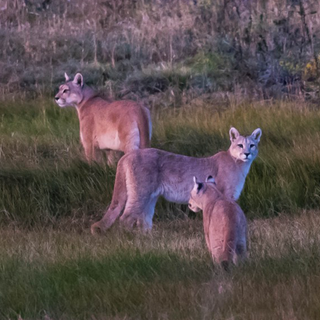
After two days of puma tracking I had had good fortune in spotting puma. A mother and three cubs the first day and four separate sightings the second day but mainly fleeting glimpses. I still was not satisfied with the images I had made…and then the third day dawned and all became right with the world. We spotted a puma about 150 meters off the track just before dawn and made our move to try to get in position for any sun that might come through in the broken clouds that were colorfully shielding much of the horizon. As I made a low approach, in cover, up onto a rocky outcropping to get into position, the lone puma we had spotted I slowly crept forward until I could just make out the cat as it was now ambling slowly down the other side of the outcropping and away. My hear sank as I thought – another butt shot of a cat moving away but just then I realized there were actually three cats in my frame. A mother and two cubs about a year old and nearly full size were all visible and moving slowly. I could not believe my luck when at the moment the cats paused to turn and size me up the morning dawn burst through the clouds illuminating the scene in front of me. I was overjoyed!!


USGS Photograph taken on May 18,1980, by Austin Post. It created the largest known debris avalanche in recorded history. The magma in St. Helens burst forth into a large-scale pyroclastic flow that flattened vegetation and buildings over 230 square miles. The eruption killed 57 people, nearly 7,000 big game animals (deer, elk and bear), and an estimated 12 million fish from a hatchery. It destroyed or extensively damaged over 200 homes, 185 miles (298 km) of highway and 15 miles of railways. (credit Wikipedia for these factoids) Though living in Seattle at the time we were away on May 18, 1980 and did not return until several days after the eruption. In the many years since - we had not visited the area so when we had the chance recently under beautiful blue April skies, we seized it and spent a few days scouting this wild area in the SW corner of Washington State. Below is what the area around the mountain looks like now. Pretty peaceful..in fact trees that were planted by Weyerhauser after the eruption are now starting to be harvested. The lumber mills are active. The valley below hides the original river beds that are now buried under more than 150 feet of mud and debris which engulfed the valley in the days after the eruption. Hard to imagine the destruction now. The landscape in the valley below the mountain though obviously recovering was completely changed forever.


Comments